Sky Path Hike Hà Giang: The Best Trail Above Mã Pí Lèng Pass
Introduction to the Sky Path Hike
Located in northern Hà Giang Province, the Sky Path is one of the most impressive hiking trails in Vietnam. The route runs high above the Nho Quế River and follows the mountains overlooking Tu Sản Canyon.
The trail sits above the famous Mã Pí Lèng Pass, a highlight of the Hà Giang Loop. While the pass attracts thousands of visitors every year, the Sky Path remains much quieter. As a result, hikers can enjoy stunning views without the crowds.
Along the route, visitors walk past limestone mountains, small villages, farmland, and dramatic cliff faces. From several viewpoints, you can admire the Nho Quế River, Tu Sản Canyon, and the winding Mã Pí Lèng Pass below.
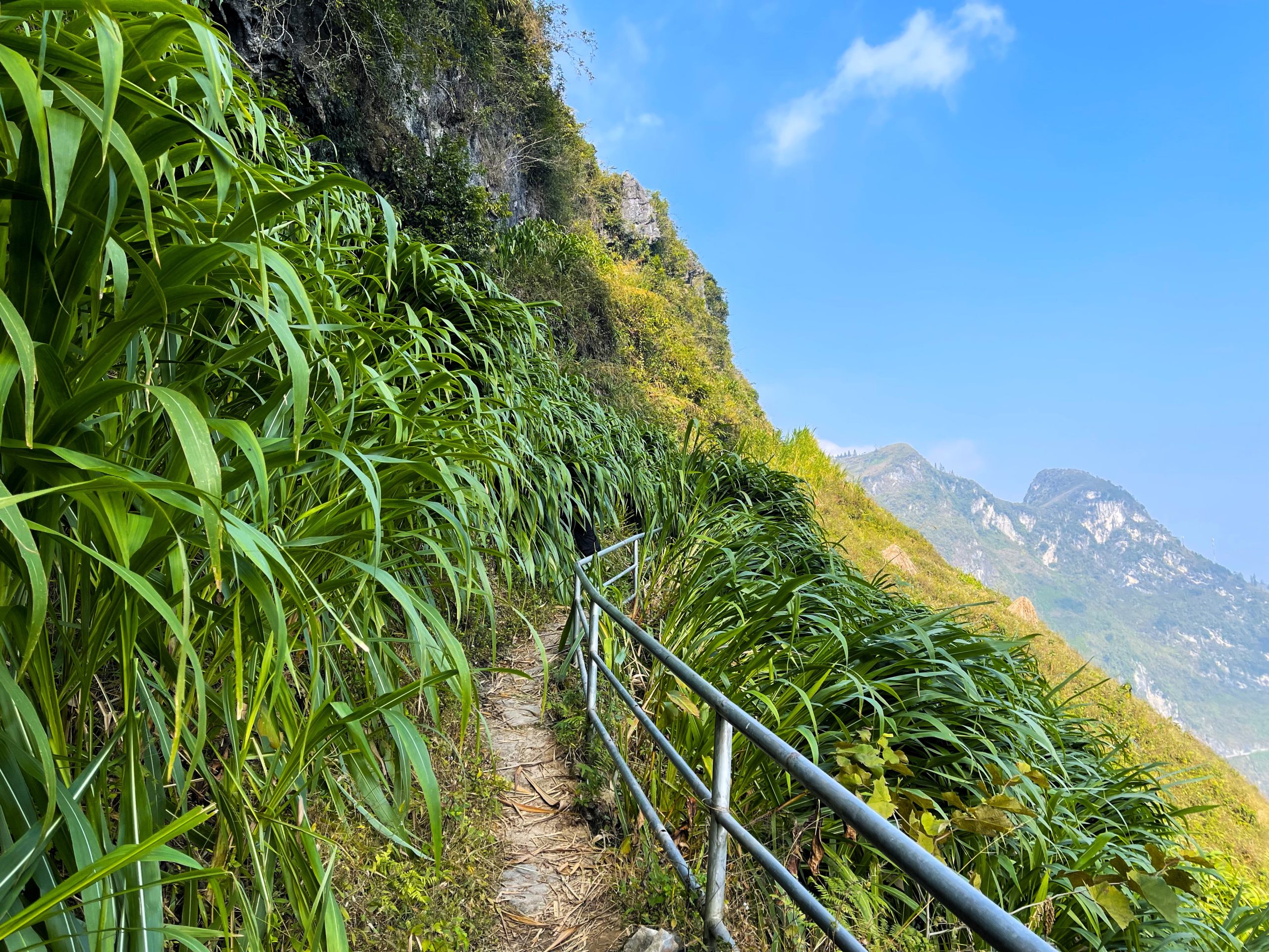
 Path hiking trail, Hà Giang
Sky Path Hiking Information
Trail Overview
The Sky Path hike usually takes between two and three hours. The exact time depends on your pace and how often you stop for photos.
The trail is easy to find and does not require a guide. Most visitors travel to the trailhead by motorbike, car, or bicycle.
You can hike the Sky Path throughout the year. However, spring and autumn generally offer the most comfortable conditions. Summer can be hot, while winter is often cold and foggy.
Avoid hiking during heavy rain or storms because rocks and paths may become slippery.
Before starting the hike, bring:
- Drinking water
- Sunscreen
- Comfortable walking shoes
- A camera or phone for photos
The route shown on most maps is only approximate, so pay attention to trail signs along the way.
Important Safety Warning
Do not attempt to ride a motorbike on the Sky Path.
Although some sections appear suitable for motorcycles, the route becomes narrow and dangerous further along the trail. In addition, local communities prefer visitors to explore the area on foot.
The most scenic section near the White Cliffs is only accessible by walking.

Walk the Sky Path high above the Mã Pí Lèng Pass
Starting Point for the Short Hike
Mã Pí Lèng Homestay
For the shorter version of the hike, start at Mã Pí Lèng Homestay.
This is one of the easiest places to park. The staff speak English and are familiar with hikers using the trail.
Many visitors stop here for breakfast or coffee before starting. You can also arrange lunch for after the hike.
The homestay offers beautiful mountain views. In addition, the balcony provides an excellent place to relax before or after the walk.

The Mã Pí Lèng Homestay is at the trailhead for the shorter Sky Path hike; riders can park here

Starting Point for the Long Hike
Youth Monument
For a longer hike, begin at the Youth Monument, also known as the Happiness Road Museum.
The monument honors the workers who built the historic Happiness Road connecting Hà Giang and Mèo Vạc. Several workers lost their lives while constructing the road through the mountains.
This starting point is closer to Đồng Văn. However, parking and luggage storage options may be limited.
From the monument, simply follow the road marked on Google Maps. Along the way, you will pass several viewpoints, including Mỏm Đá Tử Thần.
Eventually, you will reach the main Sky Path junction.


Walking the Sky Path
Through Villages and Farmland
If you begin at Mã Pí Lèng Homestay, walk uphill toward Đồng Văn.
After two sharp bends, look for a narrow trail leaving the main road. The path quickly becomes quiet and traffic-free.
The route passes small valleys, local farms, and remote mountain villages. Several trail junctions appear along the way. However, most wrong turns end quickly, making navigation relatively easy.
As you continue, impressive limestone formations rise above the path.


Climbing Toward Vách Đá
Eventually, you will reach a small village and a sign pointing toward Vách Đá.
From here, the trail climbs steadily through farmland. The higher you go, the better the views become.
Looking down, you can see vehicles moving along Mã Pí Lèng Pass hundreds of metres below. Although traffic noise occasionally reaches the trail, the route becomes quieter as you move further into the mountains.


Great White Cliff Viewpoint
One of the most famous viewpoints on the Sky Path is the Great White Cliff.
A metal handrail marks the beginning of this section. The path then follows the mountainside through patches of forest and corn fields.
The scenery becomes increasingly dramatic as the white limestone cliffs come into view.
This section offers some of the best photography opportunities on the entire hike.
White Cliff Grotto
A Natural Rest Stop
Soon after passing the viewpoint, hikers reach the White Cliff Grotto.
This natural rock formation creates a sheltered area beneath the cliff face. Long limestone formations hang overhead, creating a unique landscape.
Many visitors stop here to rest, drink water, and enjoy the panoramic views.
Because of its location, the grotto also provides welcome shade on hot days.


Tu Sản Canyon Viewpoint
Continue along the cliffside trail with mountain views stretching across the valley.
Local farmers often work nearby, growing corn and other crops on the steep slopes.
Further ahead, you will reach the Tu Sản Viewpoint. A small pavilion stands here and offers excellent views over Tu Sản Canyon and the Nho Quế River.
This is one of the most rewarding viewpoints on the entire route.
Returning to Mã Pí Lèng Pass
Final Section of the Trail
After the viewpoint, the trail descends toward a small village.
You will pass local homes, farm animals, and a small stream before reaching a T-junction.
Turning left leads to Mã Pí Lèng EcoLodge and its café. Turning right returns to the main road more quickly.
Once back on the road, you are approximately 2.5km from Mã Pí Lèng Village.
Most hikers either walk back along the road or ask passing riders for a lift. If you started at the Youth Monument, expect a longer return journey of around 5km.


Final Thoughts
The Sky Path hike is one of the best outdoor activities in Hà Giang. It combines spectacular mountain scenery, quiet trails, and unforgettable views of Mã Pí Lèng Pass, Tu Sản Canyon, and the Nho Quế River.
0 Comment